Saturday, October 20, 2012

Kayaking Wilson Creek and John's River in NC

Need to know data to plan your Kayaking trip the the Wilson Creek Wild and Scenic River and Johns River in Caldwell   County North Carolina.


With rapids ranging from Class I to V, Wilson Creek is a popular destination for kayakers and features some of the best scenery, rapids and exceptional water quality in the Blue Ridge Mountains. In addition to Wilson Creek, there are plenty of other river systems to paddle nearby. Other streams include North Harper Creek, Gragg Prong, Rockhouse Creek, Lost Cove Creek, and Johns River. Guided trips are offered by Wahoo’s Adventures. The best accomdations in the area are the Brown Mountain Lodge Cabin rentals. Paddlers should be aware of private property that runs through Pisgah National Forest in the Wilson Creek area.  Link to website, click here:       Brown Mountain Lodge Cabin Rentals

BML

CCC

Amazing Wilson Creek Kayak head cam video tour click below


                                     Wilson Creek put in locations:


Wilson Creek

Upper portions (section 1) of this stream are technically challenging and can only be paddled during heavy rains. In sections before the gorge (section 2 & 3), low- to intermediate-skilled paddlers will find a few challenges and the occasional ledge. The gorge (section 4), being one of the more popular runs in the Southeast, should only be paddled by more experienced enthusiasts, especially after a large rain. The gorge offers several major drops with Class IV and V rapids. After the gorge (section 5), Wilson Creek can be enjoyed by intermediate paddlers with Class I to II rapids.

Section 1: FS 45 to intersection of NC 90 & FS 981  
Section 2: Intersection of NC 90 and FS 981 to CR 1328 Bridge
Section 3: CR 1328 Bridge to the National Forest Service Boundary sign
Section 4: National Forest Service Boundary sign to Brown Mountain Beach
Section 5: 200 yards above CR 1337 Bridge on CR 1328 to CR 1438 Bridge at Johns River

> Wilson Creek Gage Information

       John's River smooth water kayaking and creeking


Video Tour of the Johns River click below:


Johns River
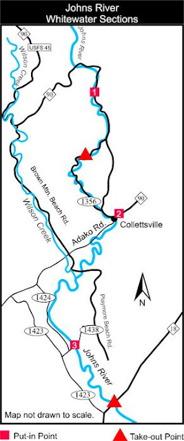
The Johns River (Class I to II) is perfect for beginner and intermediate paddlers. It runs from the Globe area of Pisgah National Forest and joins Wilson Creek and continues on to Lake Rhodhiss, north of Morganton. The upper portion (section 1) starts at the Johns River Camp bridge and runs through several low-water bridges and takes out at the bridge on CR 1356 southwest off NC 90. After a gap, section 2 starts at Collettsville at the Adako Road bridge at NC 90 and takes out at the beginning of section 3. In section 3, paddlers put in at the CR 1438 bridge and take out at the North Carolina Wildlife Access Area at the NC 18 bridge northwest of Morganton.

Section 1: Johns River Camp bridge to second low-water bridge after leaving NC 90
Section 2: Caldwell CR 1337 Bridge (Adako Rd.) in Collettsville to Burke CR 1438
Section 3: Burke CR 1438 Bridge (30 yards upstream on east bank) to NC Wildlife Access area at NC 18 bridge.

Brown Mountain Lodge Pet Friendly Cabin Rentals are located in the Wilson Creek Wild and Scenic River Gorge.

         After a fun day on the water chillaxing by the firepit grill steaks is what its all about.

                          Website link to Brown Mountain Lodge Cabin Rentals click here

CCC Outdoor firepit and lounge

BML Outdoor Firepit and Lounge

CCC Outdoor hangout by creek

BML Charcoal Grill added at BML

Wednesday, October 17, 2012

Brown Mountain OHV ATV Park Brown Mountain NC

Take the video head cam tour of the Brown Mountain OHV/ ATV park and see what the trails look like before your adventure!

Courtesy of Brown Mountain Lodge Cabin Rentals in Wilson Creek River Gorge


Just bought a UTV to bring up here and explore, I came last weekend and was blown away with the cool trails and sights,  so far I've only explored trail # 1 but its very manageable and awesome, love the views.  Bring your ATV, UTV or off road 4X4 up for some fun!


Jeep trails video click above

Important Info to know before coming:


Brown Mountain Off-Highway Vehicle (OHV) Area, on the Grandfather Ranger District of the Pisgah National Forest, offers 34 miles of rugged, mountainous trails with lots of challenges. The trails range in difficulty from “easy” to “difficult.” Note that the trails are color coded on the map to show their difficulty. The map also has vehicle symbols to show which trails are open to trail bikes, allterrain vehicles (ATV’s), 4-wheel drive vehicles, or all three. Mountain bikers may use trails at their own risk; the same fee is required.
All 34 miles of trails are open to trail bikes, while over 14 miles are open to ATV’s. Jeeps and other 4-wheel-drive (4WD) vehicles may use trail 8 and part of trail 1. Trails 1a and 1b are only open to
trail bikes and ATV’s. OHV’s may not be ridden on the access road, 299, from the highway. Most trails are not wide enough for two-way traffic, so a one-way system is provided. The trail numbers can only be seen when traveling in the correct direction. Please observe the one-way signs, but be alert for people who may accidentally travel the wrong way. Brown Mountain OHV Area is the
only place in Pisgah National Forest where ATV’s and unlicensed trail bikes may be ridden. On forest roads outside this area, only licensed, street-legal vehicles may be ridden. State vehicle laws are enforced on forest roads.

ATV Head cam video tour


Before you haul:

Call Before You Haul: Due to weather conditions and maintenance, this trail may be closed on short notice. Before your ride, please call the OHV hotline at 828-652-2144.

Length: 34 miles

Surface: Dirt and Rocks

Fees: A fee is charged for use of the trail system. Daily or seasonal passes may be purchased at local vendors or at the Grandfather District Office at 109 East Lawing Lane, Nebo, NC 28761. The District is at exit 90 just off U.S. 40 and is open Monday through Friday, 8 a.m. to 4:30 p.m. The funds are used to maintain the trails and make improvements in the area.

Season: Brown Mountain OHV Area is open this year from April 1 through January 1.


Amenities:

Primitive camping is permitted in the OHV area. Designated sites are located along the entrance road. Each site has a table, grill, and lantern post. A picnic shelter, water
hydrant, and “sweet-smelling” vault toilet are located at the trailhead. Alcoholic beverages are not permitted in the OHV area, including in campsites or on trails.
Please take your trash with you. When you are away from the toilet, be sure to bury everything, including toilet paper, at least 200 feet away from the creek. Don’t drink
untreated creek water.


National Forests in North Carolina
160A Zillicoa Street
Asheville, NC 28801
828-257-4200
 

Grandfather Ranger District
109 East Lawing Drive
Nebo, NC 28761
828-652-2144


Directions: From Lenoir:
Take Highway 90 west to Collettesville. Turn left on Adako Road (SR 1337) just beyond the
elementary school and grocery store. Travel 4.4 miles to the Brown Mountain OHV Area entrance
on the right at the sign.


From Morganton:
Take Highway 181 north about 11 miles toward Linville. Turn right on Brown Mountain Beach
Road (SR 1405) at a small wooden church on the right. Travel 3.5 miles east to the Brown
Mountain OHV Area entrance on the left at sign.

Best cabin rental accomodations in the area are the Brown Mountain Lodge Cabin rentals:

Check us out below:


Book your Land Rover/ Jeep/ ATV excursion and get your accomodations at the Brown Mountain Lodge Cabin rentals, click link below to website home page:


BML

CCC

Outdoor lounge at BML

Newly added Charcoal smoker grill at BML

Outdoor fire pit at CCC under Outdoor Lounge

CCC Chillaxing zone


Monday, October 15, 2012

Researchers trying to disprove the Brown Mountain Lights

The Legend of the Brown Mountain Lights in NC Mountains.

The paranormal folks and research gurus are still trying to disprove the local legend of the Brown Mountain Lights.  I wrote a story about them in a ghost story book titled "Thirteen Terrifying Tales of the NC Piedmont" story #10.  What I saw up close as teenager was not any kind of man made light source.


http://salisbury.wbtv.com/news/arts-culture/75587-new-research-brown-mountain-lights?fb_action_ids=4793844329756&fb_action_types=og.likes&fb_ref=.UG2Yl5gNJdY.like&fb_source=timeline_og&action_object_map=%7B%224793844329756%22%3A354153004676938%7D&action_type_map=%7B%224793844329756%22%3A%22og.likes%22%7D&action_ref_map=%7B%224793844329756%22%3A%22.UG2Yl5gNJdY.like%22%7D 

We had hiked up School House Ridge behind Mortimer campground and made camp one eve.  We had our campfire and camp site set for the eve.  As anyone who has hiked the Wilson Wild and Scenic River Gorge area will tell you it gets really dark when the moon isn't out. 

As the night settled in and we were huddled around the campfire we heard what sounded like foot steps coming up the mountain through the leaves.  Leaves crunching as if it were footsteps.  I've been coming up here for 40 years I was always told the Legend was Indian squaws looking for thier Braves lost in battle.

We could see the 3 lights that had a irredecent multi colored glow, somewhat like the size of a lantern light approaching.  These were no lanterns!  Literally the lights continued to get closer and closer.  We threw rocks sticks and any and everything we could find at them, they got to within 30 yds of us and vanished.

Needless to say we stayed up the rest of the night to keep a look out and at sun up virtually ran down the mountain to get out of there with our lives.

If your looking for the perfect secluded Mountain getaway check out our cabin Rentals located in the Wilson Creek Wild and Scenic River Gorge web site link below:

                                 Brown Mountain Lodge and Creekside Cozy Cabin Rentals

The local News Channel 36 did a broadcast of the story and its on you tube video here:


To see the Brown Mountain Lights from a distance there is a lookout on Highway 181 out of Morganton in Burke County, looking North from the vantage point is the Brown Mountain and surrounding peaks.  You might get lucky enough to see them.

Here is the link to the Burke County Information regarding the Brown Mountain Lights Phenomenon:


For best accomdations in the area check us out at Brown Mountain Lodge Cabin Rentals:


BML
CCC
CCC Outdoor lounge with fire pit

BML Outdoor lounge with fire pite and grills

BML Newly added charcoal Grill

Book your Brown Mountain lights cabin rental with Brown Mountain Lodge Cabin Rentals:


Sunday, September 23, 2012

Earth's Equinox and guide to fall colors in NC Mountains. Fall Equinox starts Sept 22 and Spring Equinox on March21

Brown Mountain Lodge and Creekside Cozy Cabin cabin rentals guide to see peak color in the Blue Ridge Mountains of NC.  See tons of pictures and details of our cabins and calendar of  availability at:                 Brown Mountain Lodge Cabin Rentals

I've been coming to the mountains since I was kid and up here every couple weeks and over the years have determined the basic cycle to the color at different elevations.  For starters though here is a diagram of what happens in the heavens and the earth passes over the celestial equator and changes us from Summer Soltice to Fall:


The Spring and Fall Equinox:

The seasons will change this Sunday (Sept. 22), with the Northern Hemisphere moving into autumn and the South emerging from winter into spring.
The celestial event that marks this transition is called an "equinox," and it happens twice every year, around March 21 and Sept. 21. Just what is an equinox, and why does it occur?
The Earth moves in two different ways. First, the planet spins on its polar axis — a line through the north and south poles — once every 24 hours, causing the alternation of day and night. Secondly, it moves in its orbit around the sun once every 365.25 days, causing the annual cycle of seasons. The equinox occurs when these two motions intersect. [Season to Season: Earth's Equinoxes & Solstices (Infographic)]
Because the Earth is so big, its mass has an enormously powerful gyroscopic effect. For this reason, its poles always point in the same direction, although a major earthquake can cause tiny wobbles in this axis. Most importantly, the Earth's motion around the sun has absolutely no effect on the direction the poles are pointing, which has very important consequences for Earth's seasons.
Astronomers mark the positions of objects in the sky relative to the Earth's poles of rotation (those are the red lines you see in the picture). The most important line is the celestial equator, which divides the sky into the Northern and Southern Hemispheres.
The Earth's pole of rotation is tilted 23.4 degrees relative to the plane of its orbit. This tilt is always toward the same point in the sky, called the celestial pole, no matter where in its orbit around the sun the Earth happens to be.
This tilt makes it appear to observers on Earth's surface that the sun is moving across the sky at an angle to the celestial equator. This is marked by the green line in the image, called the "ecliptic" because eclipses happen along this line.

Scenic Drives 
Fall Color Leaf Guide
 
One of the most beautiful times of the year in Western North Carolina is Autumn. The mountains seem to come alive with color. People travel from miles around just to catch a glimpse of the splendor. 
Peak foliage viewing depends on many factors. The most important factor is elevation. Trees of the same species, can peak weeks apart depending on their location. Cooler slopes, that face the north, will peak much earlier than slopes facing the sun. Certain species of trees also peak earlier than others. In addition, an early frost and unusually wet or dry summers will affect the process differently. 

Estimated Peak Viewing Times 

Higher ElevationsOctober 1 - 15
Lower ElevationsOctober 15 - 31

Scenic Drives 
Looking for that perfect autumn vista? Choose one of these scenic drives and wind 
your way through the Western North Carolina mountains splashed with the hues of 
autumn. You may also want to consider one of these craft excursions to understand 
the beauty that captures the hearts and imaginations of the region's artists and crafts 
people. 
Craggy Gardens 
Craggy Gardens is a wonderful place for viewing the late summer wildflowers and 
bright scarlet colored berries of the mountain ash. Bring a picnic lunch, hike some of 
the Parkway’s many trails and take in the panoramic views of the Blue Ridge 
Mountains. To reach this area, take the Blue Ridge Parkway north from Asheville 
for about 20 miles. (One way driving time: 45 minutes.) 
Grandfather Mountain 
From Asheville take I-40 to Hwy 70 at the Old Fort exit. Continue east on 70 to 
221 north. Take 221 to Linville Falls area. Pass the Blue Ridge Parkway and at the 
intersection of 181 and 105 look for a billboard directing you to Grandfather 
Mountain. View the native animal habitats, enjoy hiking and picnicking and test your 
courage on the mile high swinging bridge which also provides a great vantage point 
for viewing autumn’s rich colors. (One way driving time: 1 hour 45 minutes.) 
Mount Mitchell 
Take the Blue Ridge Parkway north. Exit NC 128 from the Parkway to Mount 
Mitchell State Park. This peak, the highest east of the Mississippi, provides 
sweeping views of autumn color on the slopes below. In addition to expansive 
views, the Park offers an observation tower, hiking trails, picnic areas, a natural 
history museum, and a restaurant. (One way driving time: 45 minutes.) 
Mount Pisgah/Graveyard Fields 
Take the Blue Ridge Parkway south from Asheville toward Mount Pisgah, where 
you will find picnic areas, hiking trails and a restaurant. Mount Pisgah was originally 
part of the 100,000-acre Biltmore Estate bought in the late 1800s by George W. 
Vanderbilt. Continue on the Parkway to Graveyard Fields (milepost 418) where you 
can take moderate 2.29 mile hike. Yellowstone Falls can also be seen from an 
overlook on the Parkway. Return to Asheville on the Parkway heading north. (One 
way driving time: 45 minutes.)


Wilson Creek Wild and Scenic River Gorge Corrider in Grandfather Mountain Ranger District:


Our guests favor the Wilson Creek Wild and Scenic River Gorge as well for the off the beaten path and no traffic.  The Brown Mountain Beach Road is hard packed gravel but is well maintained and is mostly public.  There are 9 miles of River Gorge with public parking and stairs to the river.  Bring your camera, the trees the leaves, the boulders and river hydraulics are amazing.  Bring a fishing rod to catch some of the coolest looking fish...... a beautiful Brown or Rainbow Trout.


Wilson Creek River Gorge


Brown Mountain Lodge and Creekside Cozy Cabin are right down the road from the The Wilson Creek River Gorge and only 13 miles to the Blue Ridge Parkway and Linn Cove Viaduct.  From there you can turn left and go see the Linville Falls and turn back to the right and go across the Viaduct and make a stop at Grandfather Mountain......breathtaking.  After that cap off the evening with mountain gear shopping in Blowing Rock and dinner at Canyon's Restuarant.

Here is Canyon's sunset view from the dining area and deck:


Canyons Restuarant View


View of Grandfather Mountain with telephoto at Canyons

For your next romantic weekend and evening camp fire and terrific accomodations in the mountains check us out at our web site:


BML

CCC
CCC Outdoor lounge with fire pit

BML Outdoor lounge with fire pit

BML newly added charcoal smoker grill

Saturday, September 22, 2012

Eastern US Continental Divide near Grandfather Mtn

             Map of the North American Continental Divides

The Continental Divide is the water shed flow of water from mountain ranges around the world.  Below is the picture fom the Divides in North America.  The Wilson Creek Wild and Scenic River starts at the top of Grandfather Mountain and traverses through the Brown Mountain area which is part of the Grandfather Mountain Ranger district and surrounded by Pisgah National Forest.
The Blue Ridge Mountains of western North Carolina and Eastern Tennessee are the result of the action of plate tectonics. The crust of our planet is composed of five primary plates, or huge pieces of rock which move very slowly over deeper layers of hot, pliable rock.  Here you can see how the Appalachains were formed.

Some of the plates are composed of heavy oceanic crust, while others are made of lighter continental crust. At the middle of each oceanic plate a large crack pours forth lava onto the ocean floor. This causes oceanic plates to expand an inch or two every year. When oceanic crust is forced against continental crust, the oceanic crust is pushed underneath the continental crust. When continental crust is forced against continental crust, huge mountains usually are formed.
The Appalachian Mountains were formed in the remote past by collision of two continental crusts. During such mountain building, huge sheets of rock are pushed over each other. A rock layer called the Blue Ridge Thrust Sheet was moved over 60 miles to cover what is now Grandfather Mountain.
These mountains were once much higher (10 times as high!) than they are today. Erosion over hundreds of millions of years has carried away most of the rocks to form thick layers of sediment all across the Piedmont, Coastal Plain, and in the Atlantic Ocean. At Grandfather mountain, erosion has worn away the Blue Ridge Thrust Sheet from over top of the underlying older rock, allowing us to study them. Geologists call this a “window” in time.
                            Here is the video of Grandfather Mountain the first Billion Years!

A 23.3-mile mountain stream, Wilson Creek was added to the National Wild and Scenic River System in 2000. Much of Wilson Creek lies within the Pisgah National Forest. The stream starts atop 5,920-foot high Grandfather Mountain, just 100 yards above the Blue Ridge Parkway. Twenty miles later, the headwaters rush through the Blue Ridge Mountains into a 200-foot deep gorge of granite bedrock.
The Wilson Creek Wild and Scenic River gorge is one of North Carolina's best kept secrets for the natural beauty and unspoiled commercialism.  The river and terrain has been a family favorite spot for exploring in the great Pisgah National Forest part of the Blue Ridge Mountains.
Here is a view of a kayaker taking in the beauty of the Gorge as the Wilson Creek has cut a path through the boulders and solid rock formations that are billions of years old.  Thees are the oldest exposed rock formations and  mountains in the world.
For perfect home base accomodations to enjoy your Mountain Adventures visit the Brown Mountain Cabin Rentals website.  Tons of pic's video and details of the Wilson Creek River Gorge area and the fun stuff to do here.  We are centrally located between Grandfather Mountain, Blowing Rock and Lenoir.

                                         Click below to view our website home page:

            Pet Friendly Brown Mountain Cabin Rentals

Brown Mountain Lodge Cabin Rentals east of the Continental Divide in the Grandfather Mountain Ranger District, located   near the Wilsons Creek Wild and Scenic River Gorge.

BML

CCC Fire pit

BML Fire pit and Grill area

BML New smoker Grill

CCC Outdoor lounge area

CCC Outdoor lounge family hangout by the creek
CCC

            Here is the link to our website of Creekside Cozy Cabin and Brown Mountain Lodge:                                www.brownmountainlodge.com/main.asp

Tuesday, September 18, 2012

Brown Mountain Lodge - Guest Reviews link to post

CHILLAXING in the Wilson Creek River Gorge - Mountain Home vacation rentals Guest Reviews Links for BML.

Here are the links available to post guest reviews for Brown Mountain Lodge:

Merchant Circle

Yelp - Reviews

Brown Mountain Lodge - About - Google+


At BML we just added a new charcoal grill as well as kitchen table.  Plenty of space and amenities for family and friends to enjoy the mountains at some of the most unique vacation rental homes in the Wilson Creek Wild and Scenic River area.  Stay with us at Brown Mountain Lodge or Creekside Cozy Cabin, Outdoor firepits for cool Fall evenings for chillaxing in the Mountains:

                            Creekside Cozy Cabin fire pit area, has gas grill as well

New Charcoal Grill at BML - Propane Gas Grill also

                                 
                                         Fire Pit at BML Gas grill swings and hammock, dart board


                                                     New Kitchen table at BML just added
  
                                          Covered outdoor Lounge area at CCC by the creek